
Why Tralee looks away from its own bay
Look at a map and Tralee appears to be a coastal town. Stand in the centre and you would never know it. The town sits at the head of a long, shallow bay that silts and drains twice a day into a maze of mudflats and channels, and for most of its history that shallowness was a commercial problem. Ships could not reach the town. Goods had to be landed downstream and carted in. Everything interesting about the western edge of Tralee — the windmill, the canal, the old railway line, the birds — comes out of that one geographical fact and the various attempts to get around it.
The result is that the best half-day in Tralee is spent heading west and north-west out of the town, on the flat, into the estuary landscape. It is easy walking or easy cycling, it is scenically quite unlike the mountains everyone comes to Kerry for, and it is where the town’s industrial past is still legible.
Blennerville and its windmill
Blennerville is a small settlement on the edge of Tralee where the road crosses the river, a couple of miles from the centre. It was, for a long period, the port of Tralee: the place where cargo was loaded and unloaded and where emigrant ships took people out of Kerry during and after the Famine years. The village is named for the Blennerhassett family, local landowners.
The windmill
What everyone sees first is the windmill: a tall white tower mill with black sails, standing on its own against the flat ground and the water, and visible from a surprising distance. It was built in the early nineteenth century to grind grain, fell derelict, and was restored in the later twentieth century as a working mill and visitor attraction. It is generally described as the largest working windmill in Ireland or Britain, and whether or not that superlative survives close examination, it is unarguably a big one.
Inside there is milling machinery, an exhibition area and, usually, material on the emigration trade that passed through Blennerville. Opening is seasonal and the hours have changed over the years, so check before you go rather than turning up in February and finding the door shut.
The setting
Blennerville is the best place to understand the shape of Tralee Bay. From the bridge you can see the channel snaking away west, the mudflats on either side, and the Slieve Mish mountains rising steeply on the southern side of the water. On a clear evening the light on the flats is remarkable. On a wet grey afternoon it is bleak in a way some people love and others find dispiriting. Both are authentic.
The ship canal
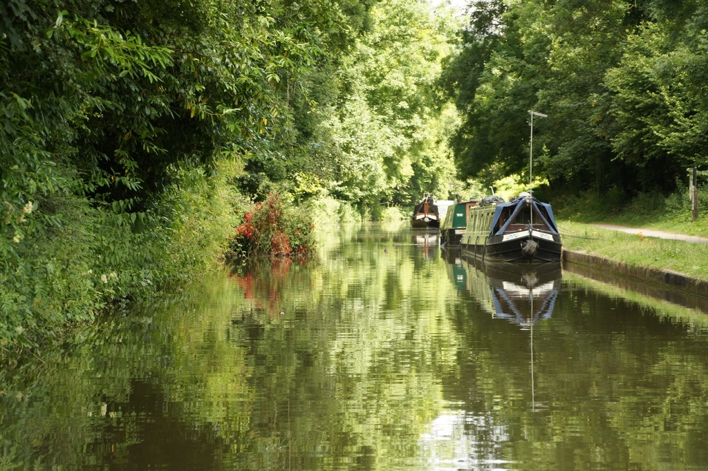
The Tralee Ship Canal was the town’s big nineteenth-century answer to its silting bay: a straight cut running from a basin at the edge of the town out to Blennerville, so that vessels could come in on the tide and unload in Tralee itself rather than downstream. It opened in the mid-nineteenth century, was used for shipping for several decades, and then declined as ships grew larger and the railways took the traffic. By the early twentieth century its commercial life was effectively over.
It survives, restored as an amenity, and it is now one of the pleasantest walks in the town. The towpath runs level and straight for roughly two miles between the basin and Blennerville, with water on one side and open ground on the other, and it is used constantly by local walkers, runners and dog owners. It takes about forty minutes each way at an ordinary pace.
Walking it
Start at the basin end near the town, walk out to Blennerville, look at the windmill, and either walk back or continue. There is no navigation involved: the canal goes one way. It is exposed, so a westerly wind is felt the whole way, and it is a much harder walk into the wind on the return than it was going out.
The greenway to Fenit
The other great flat walk out of Tralee runs north-west along the trackbed of the old railway to Fenit, converted into a surfaced greenway for walkers and cyclists. It is roughly a dozen kilometres from the town to Fenit, mostly traffic-free, gently graded because railways are gently graded, and it ends at the sea.
The old line
The railway existed because Fenit had the deep water Tralee did not. A pier was built out into the bay and a branch line ran to it, so that goods could be moved between ocean-going ships and the Kerry rail network. When that traffic ended, the line closed and the trackbed lay idle for decades before being reopened as a greenway. Knowing that changes how the route reads: the long straights, the shallow cuttings, the embankments across wet ground are all railway engineering, not path design.
Doing it on foot or by bike
- By bicycle it is a comfortable half-day. Out and back is roughly twenty-five kilometres on an easy surface with almost no climbing, which suits families and anybody who has not cycled in years. Bikes can be hired locally; availability is seasonal, so arrange it in advance in summer.
- On foot it is a serious day. Allow two and a half to three hours each way at a walking pace. Many people walk out and arrange a lift or a taxi back, or walk only a section.
- The wind decides your day. The route is open and coastal. Going out with the wind and returning into it is a very different experience from the reverse, and it is worth checking the forecast direction before you set off.
Fenit at the far end
Fenit is a working harbour and marina village with a long pier, a beach, boats and a view straight out along the bay. There is a lighthouse on a small island offshore, and a large sculpture of Saint Brendan the Navigator, who is traditionally said to have been born in this area and who, in the medieval voyage tales, sailed west from these coasts. Boat trips operate out of Fenit in season; what is running varies year to year, so ask locally rather than relying on an old listing.
The birds of Tralee Bay
The mudflats that frustrated the town’s merchants are exactly what makes the bay important for birds. Tralee Bay and the shallows around it are internationally recognised wetlands, and in winter they hold very large numbers of wildfowl and waders feeding on the exposed flats.
What you are likely to see
Brent geese are the signature winter bird, arriving from the Arctic and feeding in noisy flocks on the flats and on nearby grassland. Alongside them expect oystercatchers, curlew, godwits, dunlin, redshank, lapwing and a range of gulls, with herons and little egrets working the channel edges. In summer the numbers drop sharply and the interest shifts to breeding birds and terns.
How to watch without ruining it
- Go on a rising tide. As the water pushes in, the feeding area shrinks and the birds are concentrated and pushed closer to the shore. Low tide scatters everything far out into the middle distance.
- Bring binoculars. Estuary birding is a long-distance activity. Without optics you will see grey specks and conclude, wrongly, that there is nothing there.
- Stay on the path and keep dogs close. Disturbed flocks burn energy they need in winter, and a single loose dog can lift a whole flat.
Putting the three together
The canal, the windmill and the greenway are three parts of one story: a town trying, with increasing ingenuity and diminishing success, to reach deep water. The canal was the direct attempt, the railway to Fenit was the workaround, and the windmill is the surviving fragment of the little port that grew up while both were being argued over. Walking them in a single day, in that order, is one of the better ways to spend time in Tralee, and it costs almost nothing.
A note on the steam railway: a heritage service using part of the old narrow-gauge alignment between Tralee and Blennerville has operated in some periods and not in others. Do not build a day around it without confirming its current status locally.